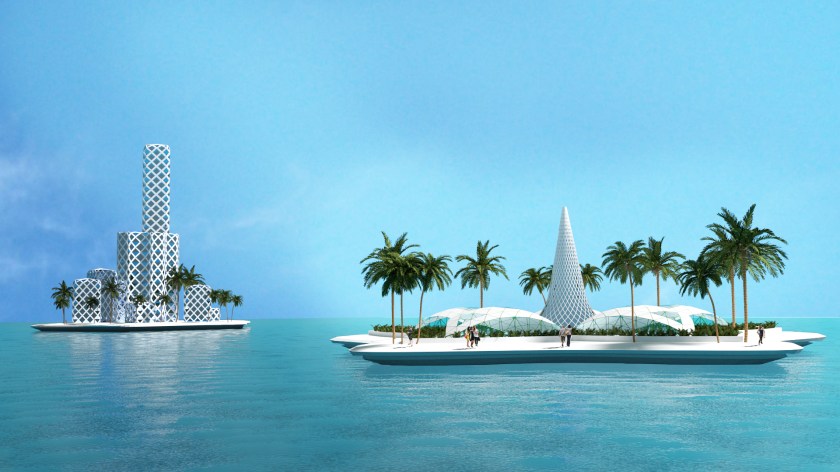
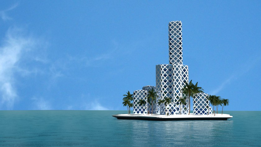
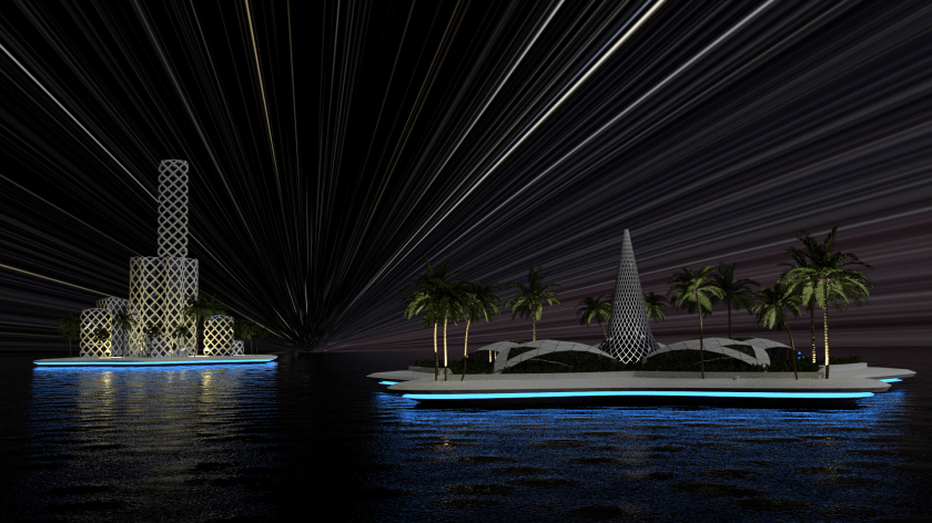
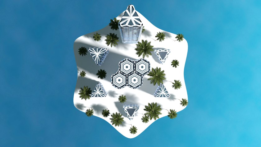
ENCLOSED OASIS

(Landscape-) Architecture

This is my graduation project for Station Nijmegen in the Netherlands.

Station Nijmegen has a surface area of circa 2 Hectares and perfectly designed for logistics, rather than the pedestrians. The area had so many little by little design revisions which led to a incoherent public space. Nijmegen is building some new amazing spaces, but the station has somehow been left behind.

ANALYSIS

ANA 2-01

L to R: Three areas, No sight, Barriers, Busroute

ANA 2-02

L to R: Pedestrian route, Sitting area/city beginning, Different architectual styles, Scale

SCALE

The station is made for dinosaurs, not for humans

THE IDEA

The most important aspects I wanted to focus on are making a pedestrianfriendly cityspace, an intuitive wayfinding towards the city, follow trough with one existing architectual style, and bringing back the size of the square to a humane scale. This is brought to life trough a few principles.

CONCEPT-01

Extrapolation of the Italian arches found on the site, which are designed by Sybold van Ravesteyn.

CONCEPT-02

Creating height differences to make smaller spaces

CONCEPT-03

Using the existing architecture to layout a grid, which gives room for arrangement of the square

Concept-01

Simplified layout

THE DESIGN

SITEPLAN

Siteplan

GRID

Grid taken from the existing architecture

AXO

Relaxing and functional area

AXO

Green/shadow and sunny/open areas

AXO

Watersystem, everything flows to the Oasis, where is being reused

AXO

airconditioning and smelltransfer with the windcatcher principle

AXO

New functions, sight, and walkingroute

AXO

Heightened busstation and route

In the Oasis

In the Oasis

Section Oasis

Section Oasis

Heightened busroad

Oasis from groundlevel

Oasis from groundlevel

Section middlesquare

Section middlesquare

Arrival on the station from the city

Arrival on the station from the city

Section functional sunny area

Section functional sunny area

Section busstation

Section busstation

Arrival from trainstation

Arrival from trainstation


LOST MONUMENTS

(Landscape-) Architecture

I started out the day with a design I had in mind for a museum. But after some mishaps with the 3d modeling software, I got inspired to make some monumental structures that are placed in the middle of nowhere. The designs are inspired by the Spomeniks which are placed all throughout former Yugoslavia.

Monument in the desert

Monument in the sea

Monument in wheat field


City-moatpark Gouda

(Landscape-) Architecture

The second assignment for the Major garden architecture was an assignment for a park on the city-moat of Gouda.

The city is famous for its cheese and stroopwafels. But the public space is not on the same level as these products. That is why the city needed a new modern design.

The location of Gouda within the Netherlands surrounded by the well known places.

Difference in outline of the peatlandscape

L to R. Enterances and route to downtown, Enterance and moat ambiance, formal outer ring and informal innerring

L to R: Greenstructure analysis, entrance and route in project area, sight from surrounding places.

Picture analysis showing the volume of an appartmentcomplex

Concept: accelerate, slowing down, and stopping

 The concept comes from the analysis that shows that the inner and outring have a difference in usage. On the outering people move quickly from A to B, while the irregular placement of trees hinders movement and promotes lingering.

The other important aspect is that the blind spot, which can connect the center with the moat. This is an area with great potential, which will vanish if a big apparmentcomplex divides and blocks the space

Masterplan partial city-moat

Cross section acceleration outerring.

Transition from existing pavement

The three zones and their function

Detail design.

On a more detailed level you see that there are three distinctive zones, eacht ment for for a different target groups. The cultural and library zone are connected by a building with a public first floor.

Lazarussteeg

Cross section Lazarussteeg

Pavement detail around the pergola

Pergola construction.

Visual Lazarussteeg.

Koningsplein

Principle section illustrating shape of the 

Detail koningsplein

Koningsplein visual

Section Koningsplein and Erasmushof

Walking route.

The walking routes decide where the placement of restaurants will be. These will be placed in the crowded area’s to promote even more lingering.

Koningsplein visual

Lazarussteeg

Detail stairs

Erasmushof visual

Foodlab Helicon Nijmegen

(Landscape-) Architecture, Masterplans, University assignments


Netherlands Project Area-01 Nijmegen-01

area slection

This is the detailed plan for The Green Factory Nijmegen. For this I chose for the area in the South. In the Masterplan this is referred to as The Restaurant. For my design I had something different in mind.

The Identity map and and Industrial map both show that there is a lot of industry on the West-side. This industrial terrain contains; metal companies, garbage disposals, car repair shops. The purple splotch in the North is now a closed coal power plant. On the Uniqueness map you can see that there are a few parks and recreation sites nearby, so that means that the site has to compete with them.

Philosophical Concept

Concept Growth and multiplication

The concept is to spread the idea of sustainable food-production in a social setting. The setting will like in the painting School of Athens. A place where people come and share ideas, but instead of the ideas being metaphysical it will be more like in the Islamic Golden age. In this age the ideas were more specific, like the discovery of the Arabic numerals, Alcohol, Algebra and naming 2/3 of the stars that we see at night.

At the Foodllab people can experiment with different ways of food-production, whereby mechanization and doing more with less is key. When children have a garden look after they score 15 points higher in the subjects math, engineering and science (As explained by Kimbal Musk).

When The Foodlab gets well known, it has the potential to grow further into the city. An important factor is that there will be no export, unless the area around the Foodlab has an abundance of food. The industrial terrain in the East will undergo change in the next 10-15 years. A lot of car repair shops will disappear, since car companies are going to shift their focus to cars without ownership. It will result in less repair shops, quicker repairs (due to smarter design) and less cars. These places that open up will gave space for the Foodlab to expand. When the City eventually becomes self-sustaining it can export their abundance to other cities to even expand even more. This will have to be through the ways of Corporate Social Responsibility.

This design fuses the idea of Jane Jacobs that cities became big because they exported more than they imported, and the idea of A. Naqvi that cities not countries, are the key to tomorrows economies.


Aquaponics

Aquaponics examples

Aquaponics is a great way to grow food sustainable, the right one is my own system. The growth is 4 weeks.

Masterplan 1 to1000

Masterplan 1:1000

Masterplan 1 to 500

Design 1:500


The Voronoi Diagram is used for this design. I was looking for a way to make the appearance of the Foodlab a surprise. The solution for this is was on the terrain all along. I had a lot of soil left when excavating for the parking-lots and (bicycle-)paths. I placed this in front of the Foodlab to create even more of a surprise. For the building I used the same voronoi diagram with the help of Voronax. It creates the optimal geometry between points trough the same proces as bubbles when they are forming.


Sideview Voronoi Forest

Sideview Voronoi Forest

Cross section Food lab

Cross section Voronoi Forest – Foodlab

Planting stamp

Planting stamp Voronoi (Food-)forest

Visual Foodlab

Visual Foodlab

Visual Voronoi Forest

Visual Voronoi Forest

The Green Factory Helicon

(Landscape-) Architecture, University assignments

This assignment was for the area around the green school Helicon. I completed this assignment with 4 other students.

The school didn’t have any interesting entrance, the school garden was without any structure and the surrounding area was not connected. From the briefing we also werte giving the fact that the surrounding neighborhood wanted to have an edible forest and an area where they can take a quick walk.

While analyzing the context we have discovered that there is an industrial site located on the west and that there is a residential area on the east. The school fell right in the middle of these two area’s. One of the other things we found is that the area did not have any inviting entrances.

We immediately  saw education as a glue for these different functions. And that was our concept for the area.

The poster (in dutch) can be downloaded here.


Farmhouse III

(Landscape-) Architecture, Interior, Projects

This is once again a impression of an old farmhouse that is in need of a renovation. it are actually two dwellings next to each other.

If you have intrest in the house, check out the website www.aelmans.com and search for Brachterzijde 16 or 17.


Brachterzijde 16.

Farmhouse exterior

Exterior

Livingroom to kitchen view

Livingroom to kitchen view

Kitchen to livingroom view

Kitchen to livingroom view

First floor

First floor

Second floor

Second floor


Brachterzijde 17

Kitchen to livingroom view

Kitchen to livingroom view

Livingroom to kitchen view

Livingroom to kitchen view

Exterior Farmhouse

Exterior

First floor

First floor


University experimentation

(Landscape-) Architecture

I started experimenting with a the beziercurve and object around path plugin in Sketchup. I made a shape and i wonderd what would it look like if I would scale it and stack it up. From this experimentation came this building. I also wanted to try to experiment with making a site map. I used high res picture from Google Earth Pro for the surrounding trees. Google earth pro can export really high resolution images and above all it is free now, you only have to type your email adress and use “GEPFREE” as the activation code.

Siteplan topview

Perspective image

Farm house II

(Landscape-) Architecture, Interior

I got an assignment from work to make a render of a old abandoned farmhouse. My render needs to show the potential of the dwelling. The last time I made a render of an old farmhouse it sold really fast, so the real estate agent hopes that the same will happen with this house.

The building is of a same type as the last one i did, its just slightly bigger. If you have interest in the house you can contact Aelmans at info@aelmans.com

Exterior render

Exterior render

View from the living room to the kitchen

View from the living room to the kitchen

View from the kitchen to the livingroom

View from the kitchen to the livingroom

Second floor

Second floor

First floor

First floor

Snowy Home

(Landscape-) Architecture

In the Netherlands we got a full 3 cm of snow this year!  That crazy amount of snow was the inspiration for this image. The modeling and rendering is done in Blender. Finding the pictures for the image went rather quickly. The only thing that took a little bit of time was bringing the colors together.

Final ImageSnowyhouse

Blender Cycles renderSnowyhouse

Geometry experiment

Other

I tried an addon for blender called Mextrude and I quickly figured that I can make some cool geometry. I played like a half hour with it and came with these results. Every shape in this post is one of the five Platonic Solids where I tried to put some fractal principles in. These shapes remind me of some spaceship or a underwater residence.

TetrahedronMex Tetrahedron

OctahedronMex Octahedron

HexahedronMex Hexahedron

IcosahedronMex Icosahedron

DodecahedronMex dodecahedron

Concept residence

(Landscape-) Architecture, Interior

This is a project im thinking about for a few years and now i picked it up again. It is a small house (9×6 meters) which i wish to build in the future. The image is an exaggerated shape study where i wanted to check the height of the curve. it quickly got out of hand which lead to this image.

The walls of the building are made with earthbags and are covered with a concrete plaster. The concept I’m thinking off is that the walls are beneath ground level. This will improve the the insulation of the building and a simple rocket stove mass heater can heat the building in the really cold days. On top of the building there is grass which will also improve insulation and integrate the architecture with the landscape

1 Bedroom

Rainy day

(Landscape-) Architecture

With this image I practiced with simulating a cloudy rainy afternoon. The building is a simple sketchup model which is inspired by the Heydar Aliyev Center by Zaha Hadid. The curved surfaces really got my attention and the next time i will try to only use curved surfaces. After the modeling I rendered the model in Kerkythea and finished it with some post processing.

Final Image

Curviloft image

Kerkythea render

Curviloft image render

Gorden Cullen Walktrough

(Landscape-) Architecture, University assignments

This image-sequence was made for an assignment for school. It is an existing neighborhood in Nijmegen Oost (Netherlands) which i remodeled using Sketchup and rendered with Kerkythea. A part of the assignment was to remove an existing building and replace it with a downloaded model or your own, I chose the latter and it can be seen on image 4.  The green (grass, trees etc), solar panels, cars, people and the Tesla superchargerstation were added in photoshop.

1CG 1 FINAL

2CG 2 FINAL

3KT CG 3 Final

4CG 4 FINAL

5CG BIRDEYE FINAL

Kaartgebied Nijmegen CG 1

Fictitious floating architecture

(Landscape-) Architecture

This is my first architectural render in Blender. The architecture is based on the Gherkin in London and the Geodesic dome. The pentagonal leaflike structures in the foreground are actually segments of the Geodesic dome and they function as study-centres for marine life. The buildings on the hexagonal floating deck are the apartments where the students can spend the night. It is completely fictional, i just had an image in my mind and tried to realize it with the Blender.

FLAOTING CITY hexabuilding2

City Dark

Topview

Topview1